OpenStreetMap
OpenStreetMap (OSM) is a collaborative project to create a free editable map of the world.
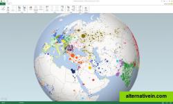
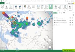
Project codename "GeoFlow" is a tool for 2013 that provides a powerful method for people to look at information in new ways enabling discoveries in data that might never be seen in traditional 2D tables and charts.
project codename "geoflow" is a tool for 2013 that provides a powerful method for people to look at information in new ways enabling discoveries in data that might never be seen in traditional 2d tables and charts. geoflow lets you plot visually, analyze that data in 3d, and create visual tours to share with others.
geoflow allows users to visually plot up to a million rows of data in 3d on bing maps, view data in a geographic space and watch change over time, and share findings through "scenes" and cinematic, guided "tours".
Discontinued maps data-visualization map-viewer offline-maps excel-add-in geographic-data 3d-data-visualization temporal-data time-stamped-data
OpenStreetMap (OSM) is a collaborative project to create a free editable map of the world.
Free Open Source Web
World Wind lets you zoom from satellite altitude into any place on Earth.
Free Open Source Mac OS X Windows Linux
Modest Maps is a small, extensible, and free library for designers and developers who want to use interactive maps in their own projects.
Free Open Source Mac OS X Windows Linux
TransforMap works towards an online platform for you to visualize the myriads of alternatives to the dominant economic thinking on a single mapping system.
Free Open Source Web
This program allows work with any maps service if you can describe getting picture by longitude/latitude(if you want you can write config file or simplepascal script to describe how obtain needle photos).
Free Windows


