Geoclip
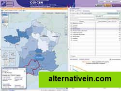
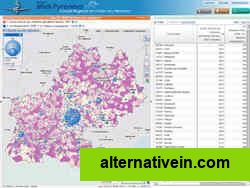
The Géoclip interactive mapping solution is proposed by EMC3. Géoclip permits to publish online thematic atlas or territorial observatories.
- Freemium
- Web
The Géoclip interactive mapping solution is proposed by EMC3. Géoclip permits to publish online thematic atlas or territorial observatories. Géoclip allows you to build web mapping applications for cartographic representations of statistical data.
Links to official Geoclip sites
Features
Categories
Productivity Developer Tools Travel and Location
Tags
database svg maps data-analysis statistics flash mapping map-online google-maps mapmaker gis kml geospatial-applications cartography webmapping wfs wms geospatal-hosting